
We use tide gauge data spanning from 2005 to 2023 in the Geosciences Laboratory at Lanzarote (Canary Islands, Spain) to perform a detailed analysis of the local short and long-term changes not previously examined in this area. Sea level is affected by the spatial and temporal climate variability on annual to decadal time scales. Consequently, the analysis of the linear trends of sea level can be difficult even when long time series are available. To achieve this objective, we investigate multi-year (from 3 to 10 years) and decadal variations of sea level through its connection with climate indexes such as the sea surface temperature, the sunspots or the North Atlantic Oscillation (NAO). First, we apply the standard corrections for the ocean tides, the atmospheric dynamics and the interannual and seasonal variability of the observed time series. Second, we study the sea level changes at multi-year to decadal scales by applying the maximal overlap discrete wavelet transform for the decomposition of the sea level signal. Furthermore, the correlations between the sea level and complementary data (sea water temperature, sunspot number and NAO Index) are investigated by means of the cross-wavelet and wavelet coherence methods. Finally, we perform a linear regression analysis of the sea level changes with the sea water temperature, including periodic components, to model the observed sea level data. Jointly with the tide gauge data, the sea level is monitored using a GNSS permanent station co-located with the tide gauge site. The study of both time series (sea level and vertical ground displacement), after removal of the previously modelled tidal and non-tidal components, provides the long-term linear trend for the complete period, from 2005 to 2023: an increase of 0.33 ± 0.06 cm/yr for the sea level and an increase of about 0.016 ± 0.003 cm/yr for GNSS-vertical displacement.
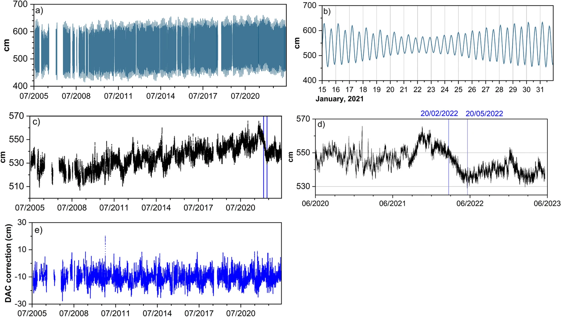
Nivel del mar observado en el sitio JA (Lanzarote), para el periodo 2005-2023. b Rango extendido para el año 2021 mostrando las mareas observadas. c El nivel del mar observado de a) tras la eliminación de las mareas. Las líneas azules indican el período comprendido entre el 20 de febrero y el 20 de mayo de 2022. d Zoom sobre los tres últimos años de c). e Corrección atmosférica dinámica (DAC) aplicada a los datos observados del nivel del mar.
Benavent, M., Arnoso, J., Vélez, E.J. et al. Peculiar Variations and Long-term Changes in Sea Level Observed in the Lanzarote Geosciences Laboratory (Canary Islands, Spain). Pure Appl. Geophys. (2025). https://doi.org/10.1007/s00024-024-03638-2
Deja un comentario

Deja un comentario